According to the Central Regional Hydro-Meteorological Station, early on the morning of November 5, Typhoon Kalmaegi entered the eastern part of the central East Sea, becoming the 13th storm to form in the East Sea in 2025.
TYPHOON KALMAEGI (STORM NO. 13) ENTERS THE EAST SEA
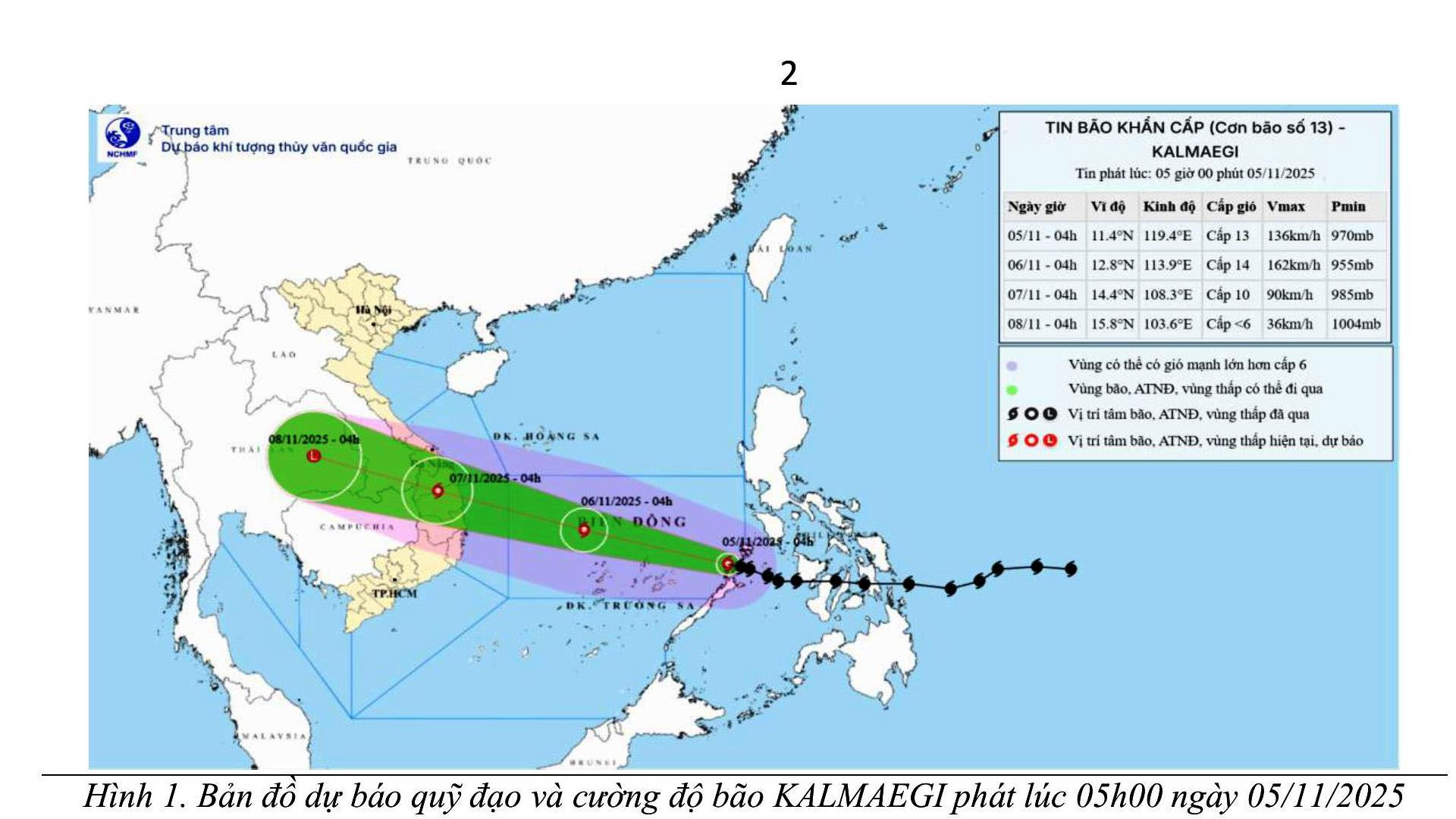
According to the Central Regional Hydro-Meteorological Station, at 4:00 AM on November 5, the center of Typhoon Kalmaegi was located near 11.4°N latitude and 119.4°E longitude, approximately 560 km east of Song Tu Tay Island.
The strongest winds near the storm’s center were at Level 13 (134–149 km/h), gusting up to Level 16.
The typhoon is moving west-northwest at a speed of 20–25 km/h.
Forecast:
- By 4:00 AM on November 6:
Typhoon Kalmaegi will continue moving west-northwest at about 25 km/h, located approximately 550 km east-southeast of Gia Lai Province’s coastline, and is likely to intensify further.
Maximum sustained winds near the center are forecast at Level 14, gusting to Level 17.
Disaster risk level: 4 for the central East Sea, including the northern waters of the Truong Sa (Spratly) Archipelago. - By 4:00 AM on November 7:
The typhoon will move west-northwest at around 25 km/h, making landfall over areas from Quang Ngai to Dak Lak, and then gradually weakening.
Maximum winds near the center are expected at Level 9–10, gusting to Level 12. - By 4:00 AM on November 8:
Typhoon Kalmaegi will continue moving west-northwest at 20–25 km/h, weakening into a tropical depression, affecting coastal areas from southern Quang Tri to Da Nang, and provinces from Quang Ngai to Dak Lak.
Marine Impacts:
Over the central East Sea (including the northern part of the Truong Sa Archipelago),
- Winds will reach Level 7–8, later increasing to Level 9–11,
- Near the storm’s center: Level 12–14, gusting to Level 17,
- Wave heights: 5.0–7.0 m, up to 8.0–10.0 m near the center,
- Sea conditions: very rough.
From early morning on November 6, the Da Nang coastal waters will see winds strengthening to Level 6–7, later increasing to Level 8–9, gusting Level 10–11; near the storm’s center, Level 11–12, gusting Level 13–14.
Storm surge:
Along Da Nang’s coastal areas, sea levels may rise by 0.3–0.6 m due to strong winds.
Warning:
Be cautious of storm surge and large waves causing inundation in low-lying coastal areas, overtopping of sea dykes, erosion, and flooding of coastal roads, as well as slower river drainage.
All boats, aquaculture farms, and coastal facilities within the affected area will be at high risk from thunderstorms, squalls, strong winds, high waves, and storm surge.
On Land:
From the afternoon and evening of November 6, the coastal mainland of Da Nang will experience winds increasing to Level 6, later rising to Level 7–8, gusting Level 9–10.
From November 6–7, widespread heavy rain is expected across Da Nang City, with total rainfall of 100–300 mm, and over 400 mm in some areas.
Due to the typhoon’s large circulation, thunderstorms, squalls, and strong gusts may occur both before and during landfall.
According to the Da Nang City Portal (danang.gov.vn)